ETA CCS Model
Eta CCS is a climate version of the NCEP Eta forecast model.
1. The Eta CCS model is made on the base of the WS Eta modeling package of
SOO/STRC (http://strc.comet.ucar) which is nearly identical to the NCEP WS Eta
operational version of 2003.
2. Our modifictions in the SOO/STRC Eta include new programs which convert the
HadAM3P global model output data to the Eta model data format, new restart
programs, new SST update programs, new preprocessing and postprocessing programs,
new programs of Sun's elevation angle, etc
( http://arxiv.org/abs/0709.2110v2).
We implemented in the model new shortwave and longwave radiation schemes.
3. The Eta CCS model with the resolution of 40 km has been integrated
continuously over South America and adjasent oceans for the current climate
period (1960-1990) and for the future time period (2070-2100) for the ISCCP
scenarios A2 and B2 with the boundary conditions derived from the output of
HadAM3P atmospheric global model.
4. The results of the analysis show that the Eta CCS model is consistent with
the outputs of the HadAM3P driving model, that the model reproduces current
climate reasonably well and that further improvement of the model performance
can be achieved by the improvement in its physics parameterization package.
5.We implemented in the Eta CCS model (as options) the new shortwave radiation schemes:
CLIRAD-SW-M and CLIRAD(FC05)-SW and the longwave radiation scheme CLIRAD-SW-M.
Analisys of impact of various shortwave radiation schemes on the precipitation rate
over South America was made.
(Performance of various radiation... .pdf)
6. We are planning to improve the Eta CCS model performance over South America
by improving the model physical parameterization package, firstly, its
radiation and convection and land-surface schemes.
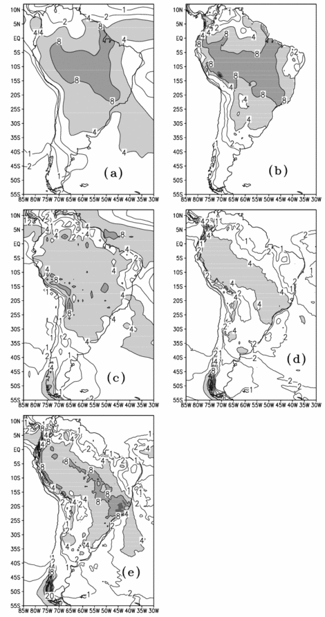
December-January-February (DJF) mean precipitation (mm/day) averaged over 1980- 1983 years: (a) GPCP observational data, (b) CRU observational data, (c) outputs of HadAM3P global atmospherical model of Hadley Center, (d) outputs of Eta CCS driven by HadAM3P output data, (e) outputs of Eta CCS driven by Reanalysis II data.
Figure 1.
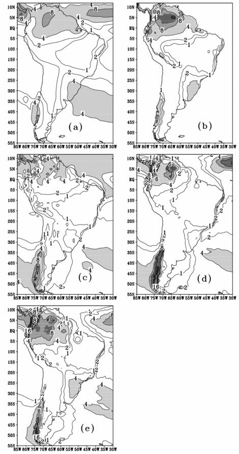
June-July-August (JJA) mean precipitation (mm/day) averaged over 1980-1983 years: (a) GPCP observational data, (b) CRU observational data, (c) outputs of HadAM3P atmospherical model of Hadley Center, (d) outputs of Eta CCS driven by HadAM3P output data, (e) outputs of Eta CCS driven by Reanalysis II data.
Figure 2.
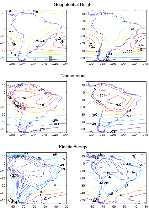
Mean (1961-1990) fields of geopotential height (m), temperature (°K), and kinetic energy (m²/sec²) at 1000 mb, provided by HadAM3P (left) and Eta CCS model (right) simulations.
Figure 3.
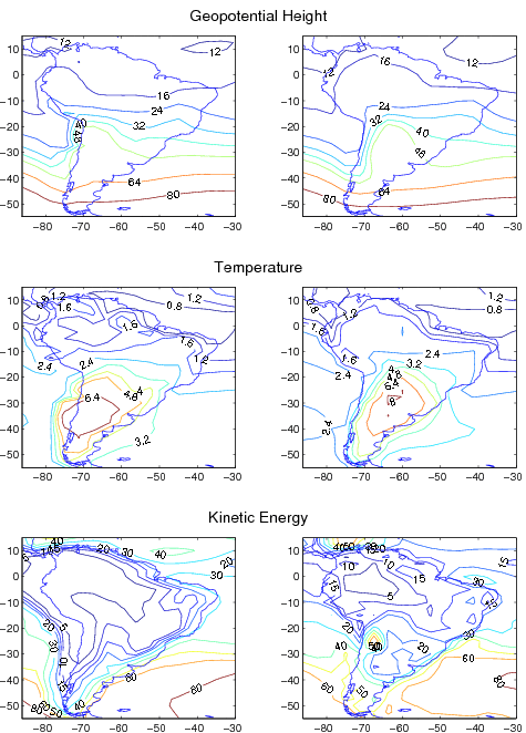
Mean (1961-1990) standard deviation fields of geopotential height (m), temperature (°K), and kinetic energy (m²/sec²) at 1000 mb, provided by HadAM3P (left) and Eta CCS model (right) simulations.
Figure 4.
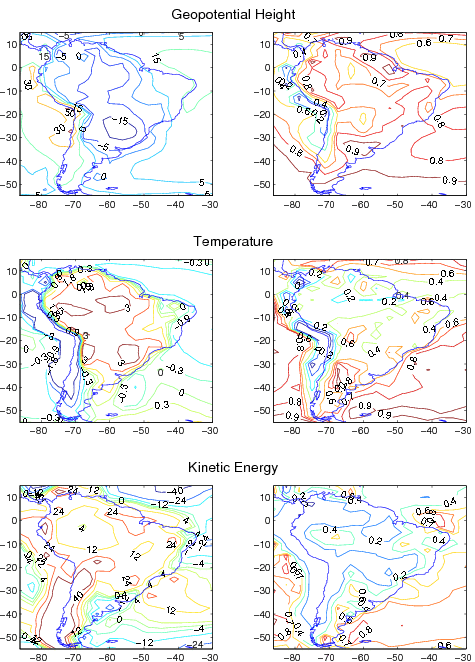
Mean (1961-1990) fields of MAD (left), calculated for HadAM3P and Eta CCS model fields of geopotential height (m), temperature (°K), and kinetic energy (m²/sec²) at 1000 mb, and consistency index between HadAM3P and Eta CCS model(right), calculated for the same fields.
Figure 5.
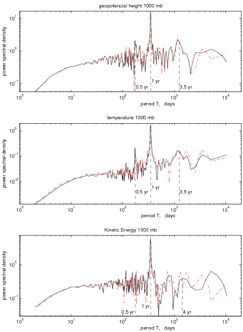
Time spectra of mean (over the integration domain) geopotential height (top), temperature(middle), and kinetic energy (bottom) at 1000 mb, provided by HadAM3P (solid) and Eta CCS model (dot-dashed) simulations.
Figure 6.

Annual cycle of monthly mean daily precipitation (mm/day) averaged over 1980-1983 years and 6 regions: Amazon(AM), North Amazon(NA), North East Brazil(NE), South Brazil(SB), South East Brazil(SE), Pantanal(PA) obtained from CRU data(dashed line), GPCP data(dot-dashed line), ETA CCS driven Reanalysis(square), ETA CCS driven HadAM3P(triangle) and HadAM3P(filled circle).
Figure 7.